Multipurpose GIS
Designed and developed Multipurpose GIS that has been used for many years to verify worldwide ARINC 424 aeronautical information, Secondary Surveillance Radar (SSR) information used by Collision Warning Systems (CWS), Terrain Awareness and Warning System (TAWS) data and software, etcetera. It was also used for creating aeronautical airspace information used in aircraft navigation systems. The GIS depicts the information being verified or created along with coastlines, rivers, islands, lakes, national boundaries, internal boundaries, airspaces, and any other information desired having Latitude and Longitude coordinates. Over the years, this GIS has detected numerous errors in information provided by the Federal Aviation Administration (FAA) National Flight Data Center (NFDC), the FAA Spectrum Engineering Division, Swissair, Racal, and Jeppesen Sanderson.
During execution, the GIS allows the user to choose between several map projections and includes zoom, pan, search, relocation, present position indication, and selections for grids and labels, text direction and justification, font type and size, Great Circle or Rhumb Lines, shape (Point, Line, Polygon) substitution, line style and width, shape color, fill color and pattern, overlays, single step or fast forward, halt, pause, continue, zoom and pan rate change, items to plot, audible sound indicators, save images to bit map files, simple animation, key command help, etcetera.
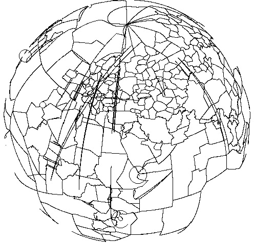
The graphic that follows shows (with no base map) worldwide FIR/UIR Airspaces using the Spherical Projection in the GIS with European countries in the center. The large spikes (extended line segments) in some of the Airspaces are serious errors in the data.
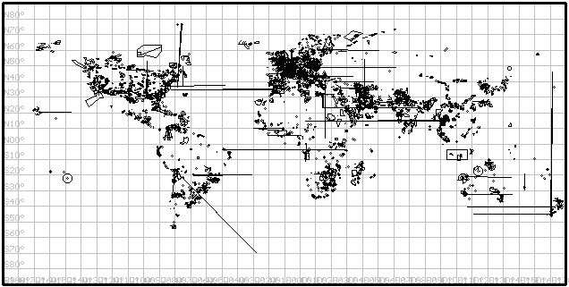
The graphic that follows shows (with no base map) worldwide Restrictive Airspaces using the Simple Cylindrical Projection in the GIS. The large spikes (extended line segments) in some of the Airspaces are serious errors in the data.
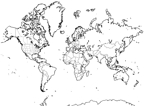
The graphic that follows shows a base map of the GIS consisting of worldwide Coastlines, Islands, Lakes, National Boundaries, and Internal Boundaries using the Mercator Projection:
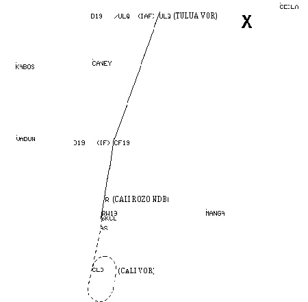
The graphic that follows from the GIS gives the Approach Route that Flight 965 had failed to make:
JavaScript with Google Maps and ESRI ArcGIS Explorer APIs
I have been using JavaScript for over 15 years on my business and many other Internet web sites. Examples include JavaScript code for zooming in and out of images, selecting between images in a set, elapsed time, etcetera, and employing the Google Maps and ESRI ArcGIS Explorer JavaScript APIs.
Aerial maps that show serious errors discovered in the latitude and longitude coordinate locations
of radars as documented in unclassified data in the public domain.
Having accurate radar location data is crucial for aircraft Collision Warning System (CWS) passive mode operation
during which the system listens to SSR interrogations and the replies from aircraft transponder.
Google Maps API is employed:
RADAR LOCATION ERRORS
Industrial Excess Landfill (IEL) Uniontown, Ohio EPA Site EPA ID# OHD000377911.
The third worst Superfund Site in the entire nation.
Google Maps API is employed:
Industrial Excess Landfill (IEL)
Wise Road Environmental Protection Agency (EPA) Site #OH0001328350.
Google Maps API is employed in the SOLUTION section:
THE GREEN HISTORY DETECTIVES Episode 23
MAP JavaScript API Comparisons.
Google Maps and ESRI ArcGIS APIs are employed:
MAP JavaScript API Comparisons
